“We view our job as abstracting away all the complexity and delivering maps that are ready to use so that growers can spend more time applying their expertise, more powerfully, and over a larger area.” – TerrAvion
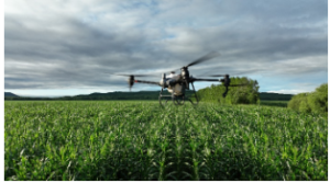
Part of the yearly struggle of developing an operational plan for your farm is determining how to most efficiently procure and apply the fertilizers, pesticides, herbicides and spot treatments to your fields. For irrigated farmland, another aspect of operational planning takes into consideration the installation, maintenance and operation of the available irrigation system. By choosing to subscribe to TerrAvion Aerial Imagery services, in partnership with MidPlains Ag, you are able to take advantage of low cost precision ag data, made simple and ready for your use, so that you can take greater, and more proactive, control of your fields.
Make sure to speak with our representatives regarding this valuable service made available to you through MidPlains Ag and TerrAvion – The Largest Volume Subscription Aerial Imagery for Agriculture Provider in the U.S.A.


